If you do not see today’s Fishing Report, please refresh your browser to empty your cache.
Welcome to the Fishing Report from Townsend, Tennessee in the Great Smoky Mountains. At 5:01 am, the temperature outside is 34.5 degrees.
Today will be cool, with a high temperature in the low 40’s. We have a slight chance for snow and rain. Both will be light. Snow accumulations are only expected in the Smoky Mountains. It snowed in the mountains yesterday morning. The higher peaks were white yesterday through nightfall. Tonight’s low temperature will fall into the low 20’s in the valley.
Tomorrow will be sunny and a little warmer. The weekend will be warmer and wet. Rain is predicted beginning Saturday afternoon and lasting through Sunday night. About ½” is expected through the period.
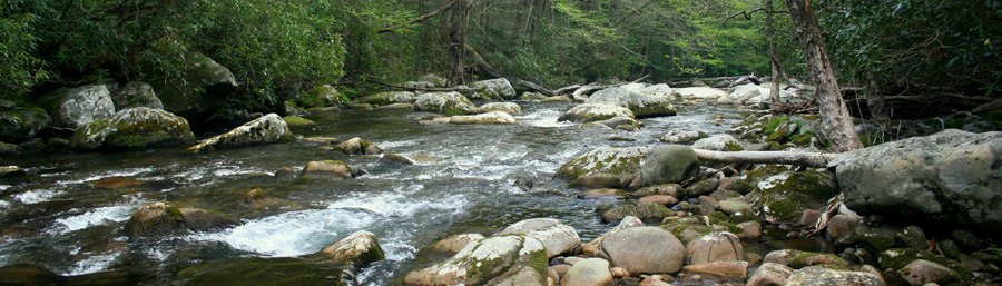
Little River is flowing at 345 cubic feet per second (cfs) or 2.34 feet on the flow gauge. Median flow for this date is 401 cfs. The water temperature is 42.6 degrees this morning.
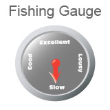
I expect fishing will be slow in the Smokies today and tomorrow, due to the cold water temperatures.
If you go, I think you will do best using nymphs, fished deep and near the bottom. The trout will be sluggish, but they might take your fly or flies. There is plenty of current in the streams. Don’t fall in. Have an extra set of dry clothing in your truck, in case you do.
Warmer days and night are just 8 days away, if the predicted weather pattern holds true. We can look forward to highs in the 60’s with lows in the 40’s, beginning Friday March 16th. Fishing will improve if that happens.
Paula and I met with Ben, from the U.S. Geological Survey (USGS) at our home yesterday. Ben and others from USGS are surveying the underground streams in Dry Valley, where we live. There are many caves here, which form near Cades Cove, not far away. We can see the mountains bordering the Park, where the cove is just across the ridge.
They have been surveying other caves on our neighbor’s property. Tuckaleechee Caverns, nearby, is one of the largest caves in the area. The current cave they are surveying, “Mill Race Cave”, runs under this property. The stream normally flows at about 12 to 25 cfs according to Ben, if I understood him correctly. During rain events, the flow is much greater. The flow for the cave empties in the Spring Creek that runs through our property. The primary source of the Spring Creek is Dunn Spring, across Old Cades Cove Road, maybe ½ mile from our house.
The original Cades Cove Road, runs along this property. Settlers in the Cove used the road to reach Townsend using horses and wagons. The old road fords the creek. Just above the ford, is an old mill dam, first built of logs, then later re-built with concrete. There, people stopped to have their corn ground.
Ben told us, an old sawmill was located at the entrance to Mill Race Cave in the 1800’s. I didn’t know that.
They have been testing the path and volume of water that emerges all around us. Using dye, they have found where the underground streams originate. If the water is stained during a rain event, they have a meter that detects the dye they can’t see. He mentioned one stream that flows at 1,000 feet per hour. I think he was talking about the stream that flows out of Mill Race Cave.
I think he said, Dunn Spring’s flow comes from White Oak Sinks, on Scott Mountain, the largest peak we can see from our house. I think that underground stream runs through Tuckaleechee Caverns. On the other hand, the water exiting Mill Race Cave, originates at Bull Cave, near Cades Cove and Rich Mountain. Bull Cave is the deepest cave in Tennessee. I read online, the depth from the entrance to the floor, is 925 feet.
It is all interesting. I told him they could park their trucks at our barn. They will be doing a physical survey of Mill Race Cave, and I should get a drawing when they are finished. I have a drawing of Short Creek Cave, also known as Butter Cave, we have to enter on our neighbor’s property, where an irrigation pump feeds our gardens.
Most of this is new information, and I could be confused about some of the facts.
Ben mentioned the USGS gauge on Abrams Creek. What? There is a gauge on Abrams Creek? Yep, they installed it last Spring. You can see the live data by CLICKING HERE. I also added a link below, in the USGS Gauge section on this page.
I forgot to ask where exactly the gauge site is located. So, I copied the coordinates into Google Earth and found it. Here are the coordinates: 35°35'35" N, 83°50'42" W
It is not located where I hoped it would be. They placed it below the spring, where Abrams Creek emerges from the ground, near the Cades Cove Loop Road, before the water runs under the road. The flow does not report the data below the confluence of Mill Creek, at the Abrams Falls Trailhead. But, it offers us a decent reference for anglers who plan to fish Abrams Creek.
There is little historical data for comparison, as the gauge was installed last May. Over time, there will be comparisons, median flow for instance. Some of the gauges around here have data going back 50 to 75 years. We’ll have to wait a while for that. There is not a temperature probe at this new gauge. The water there probably stays at about 58 degrees, year round.
Anyway, I though you might be interested. I hope you are.
Have a great day and thank you for being here with us.
Byron Begley
March 8, 2018
UPDATE 7:11 AM: US HWY 441/NEWFOUND GAP RD FROM GATLINBURG TN TO CHEROKEE NC IS TEMPORARILY CLOSED DUE TO SNOW/ICE.
Respond to: byron@littleriveroutfitters.com |